Almost four decades of climate data has been used to test the suitability of wave energy infrastructure development off the coast of southwestern Western Australia with scientists uncovering seasonal trends that suggest the site is ripe for development as the newest source of renewable energy in the state.
A team from the University of Western Australia took 38 years of data from the Centre for Australian Weather and Climate Research (CAWCR) and fed it into a numerical wave model known as Simulating WAves Nearshore, or SWAN, to determine seasonal and interannual variability in the wave climate and wave energy resource for the site, located near Torbay, found 20 kilometres west of Albany.
The research revealed a trend of storms receding from the WA coastline over time, proving promising for the development of the wave energy site and the extraction of energy with fewer extreme weather events impacting the region. The study also unveiled how seasonal variations shifted from season to season and from year to year, providing a powerful tool in the predictability of these weather events in the future.
Drilling down to the details
The research was one of the first to be done on wave energy on a purely site-specific basis within Australia and aimed to fill a knowledge gap caused by prior studies solely looking at larger scale areas, Michael Cuttler, lead author of the paper1 and researcher at the UWA’s Oceans Institute, told Lab Down Under.
With interest in the Torbay site by the WA state government and a number of wave developers, there was a good motivation to delve into the detail about the overall ocean and weather dynamics in that region, Cuttler said.
“You really want to drill down to the highest resolution possible to resolve everything that’s going on at that specific site, examining how local bathymetry and other sorts of effects could potentially differentiate that location and focusing on aspects that might get averaged away in larger scale studies.”
The Torbay site was found to have a continually high level of wave energy flux (effectively the rate of wave energy moving through a one square metre area) that was unusually consistent compared to other potential sites globally. Ninety-two per cent of the area was suitable for most commercially available wave energy converters (WECs), the study found, as the waves were the right height and the overall conditions were not too extreme.
“Some converters might be more situated to low energy regimes whereas others may be specifically designed for higher energy regimes. They might have variable optimal conditions where they really perform well. You can go around the Torbay embayment and find the whole suite from very small to very large, but all with consistent wave energies. Torbay was quite a cool testing ground for a whole range of converters,” Cuttler said.
“One of the stormiest areas of the ocean”
Sites like Torbay offered great potential for wave energy farms because of the sheer amounts of wave energy tracking in from across the Southern Ocean, Cuttler told Lab Down Under.
“It really is one of the stormiest areas of the ocean globally, with one of the largest fetches and potential for wave generation. Southwestern Australia is directly in the impact zone for many of the storms that come across from the Southern Ocean. That’s why being situated within this storm belt means the whole southern margin of Australia experiences large quantities of wave energy.”
The research found that Torbay had the “largest potential resource” of any previously studied location globally. To maximise this resource, the WECs could be arranged in arrays or ‘farms’ tailored to different regions around the bay area that had various levels of wave energy flux.
While the study only examined Torbay in particular, the regional picture would be similar, Cuttler said, although he noted that further studies could be needed for other locations along the coast before their suitability as the site of a wave energy farm could be confirmed.
The climate driver you’ve never heard of
The reason why Torbay is such an ideal spot for wave energy is because of the interplay of two key climate features, the sub-tropical high pressure ridge (STRP) and the Southern Annular Mode (SAM), which the study found periodically regulated the area’s wave energy and provided an opportunity to predict the wave climate.
The STRP is a region of high pressure falling air that extends all the way around the globe between about 23°S and 66°S and generally sits over Australia. It can shift and move depending on other climate influences and typically brings warm, dry weather and westerly winds with it.
The position of the STRP is closely correlated to the Southern Ocean storm belt, also known as the ‘roaring forties,’ which brings strong westerly winds and eastward travelling swells.
The SAM is a climate driver of the STRP, moving the ridge north and south in seasonal cycles. A positive SAM means the STRP moves further south over Australia, meaning winters will be dry and summers will be wet in the south of the continent where Torbay is located.
On the other hand, a negative SAM shifts the STRP further north over Australia, meaning that winters will be wet and summers dry, essentially having the opposite effect of the positive SAM.
“When you’re in a positive SAM phase, those westerly winds will move further south which we were finding was potentially causing some of the storm systems to miss Torbay so we got a change in the wave direction and a decrease in the wave energy,” Cuttler said.
“When you have a negative SAM, those westerlies move closer to the southern Australian margin which means that the storms are going to be more directly impacting that southern region. We saw that related to wave directions from the southwest that were much larger as well.”
Studying the past to predict the future
This research has created a model that now allows developers to test the performance of different WECs at various positions over a range of conditions around Torbay without having to physically place anything in the water, Cuttler said.
As for what the next steps were personally, Cuttler said he would be focusing on new areas of study using the CAWCR data and hindcast modelling, specifically looking at wave climate variability over the last four decades and its effect on near shore coastal processes such as sediment transport, erosion and other types of shoreline variability.
“We’ll be using this data to actually embed wave energy converters within different models to look at how those waveforms might impact coastal dynamics and other things within the system,” he said.
With SAM affecting the overall wave direction, it was clear that a more positive SAM and the subsequent southerly waves would have implications for the direction of sediment transport and begin eroding areas which had not experienced erosion previously, Cuttler added.
“There is actually a long-term trend of a more positive SAM so it is likely that the waves down there will potentially continue to become more southerly. That’s an active area of research for us. I always think you have to have a good understanding of the past before you can predict the future and so we’ll definitely be trying to look at any historical shoreline variability and relate that to our model before we start forecasting forwards.”
CAWCR was a collaboration between the Commonwealth Scientific and Industrial Research Organisation (CSIRO) and the Australian Bureau of Meteorology (BOM). The hindsight data gathered from CAWCR is still being updated however as more weather information is gathered.
Author’s note: If you enjoyed this article, you can follow Lab Down Under on Facebook or support me on Patreon. I also have my own personal Twitter account where I’ll be sharing my latest stories and any other items of interest. Finally, you can subscribe here to get my weekly blogs in your inbox.
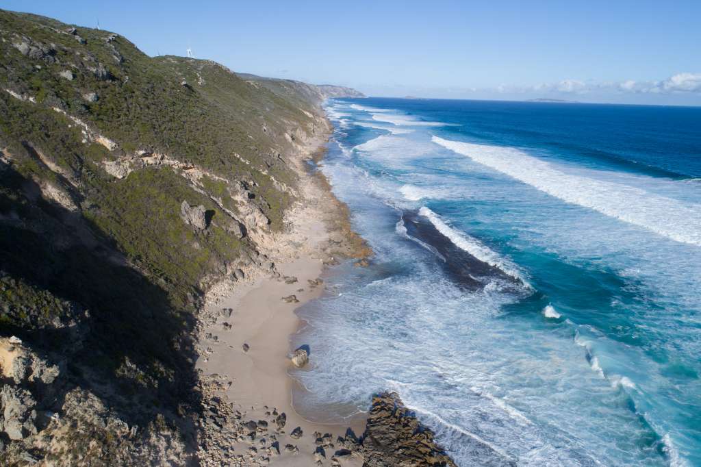
Featured image: Coastline near Torbay. Picture by Michael Cuttler.